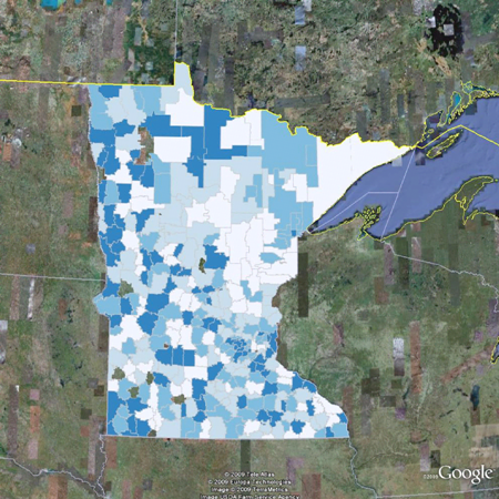
With spring semester in my rear view mirror, I found some time to use the ![]() maptools package to make a proficiency map that can be displayed in Google Earth. It’s essentially a choropleth map in Keyhole Markup Language (KML) format. Google Earth takes visualizing educational outcomes to a whole new level. Distributing proficiency maps in KML format would make it easy for parents, school district employees, policy makers, and students themselves to explore their district’s test scores and those of nearby districts. Additionally, KML proficiency maps could help evaluators of educational programs involve stakeholders and frame questions.
maptools package to make a proficiency map that can be displayed in Google Earth. It’s essentially a choropleth map in Keyhole Markup Language (KML) format. Google Earth takes visualizing educational outcomes to a whole new level. Distributing proficiency maps in KML format would make it easy for parents, school district employees, policy makers, and students themselves to explore their district’s test scores and those of nearby districts. Additionally, KML proficiency maps could help evaluators of educational programs involve stakeholders and frame questions.
Try it for yourself. You can click on the image below to explore Minnesota’s 3rd grade math proficiency results with Google Earth. After you’ve gotten your fill of zooming around the map, try the following:
- Click on a district to activate a pop-up window containing the district’s name and results.
- Click on the “+” sign next to “2007 Minnesota Comprehensive Assessments (MCA-II)” under the Places sidebar. The district results will expand downward, showing results in tabular format with map links. Double-click a district name in the sidebar to zoom to that location.
- Use the Search -> Find Business section of the sidebar to find an after school tutoring program in a district of your choice.
Minnesota school districts: Math proficiency among third graders
Please leave a comment if you have any feedback about this approach.