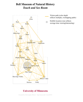
Frances Lawrenz is one of my advisors. She knew about my interest in spatially enable evaluation and put me in touch with Bob Tornberg, a graduate student in Educational Policy and Administration who was leading an evaluation for the Bell Museum of Natural History. I had been looking for an opportunity to apply mapping and/or spatial analysis to a micro-level evaluation setting, such as a classroom. Bob wanted to give the primary intended users (PIUs) of the evaluation some information about paths traveled by visitors to the museum’s Touch and See Room. Spatially enabled evaluation sounded like a mutually beneficial approach, so we decided to collaborate. I’m glad that Bob involved me before data collection began because I was able to suggest data recording procedures that later facilitated the mapping and analysis. I don’t think it would be appropriate to share the statistical results here, but I think it’s okay to share one of the maps. I think the maps turned out well, and I’m looking forward to hearing the PIUs’ impressions.